
Isotherms are contour lines that connect points of equal temperature.


 http://www.neiu.edu/~jrthomas/377/circle.jpg


 http://www.plu.edu/~alberttl/img/map.jpg


A hypsometric map uses contour lines and sometimes color to show elevation. This map easily shows the different elevations and it can be seen where the mountain ranges are and the flat interior.


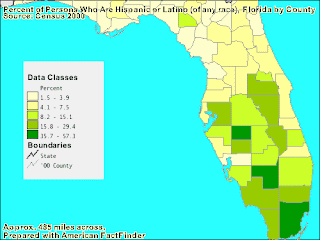
A cadastral map is used to divide land and show ownership. This map divides each county into different segments.


A topographic map is used to display the physical elevation of land. This map shows the different elevations of the state of California.


